The town now known as Biddulph was created in 1897 when the villages in the Biddulph valley were joined as one Urban District. The villages are Biddulph Moor, Biddulph Park, Brown Lees, Gillow Heath, Knypersley and Bradley Green – the place where the town centre now stands and which now no longer exists except in people’s memories and in the name of a High Street pub.
In 2003 the Town Council supported ideas for village signs which would represent the character of each of these areas. The following were chosen.
All the signs have features in common and are intended to give information about the history and geography of their area. Each sign has a frame which relates to some aspect of the “village”, each sign contains the picture of a building in the area, if there is a coat of arms which belongs to the area it is shown on the sign. Any special feature of the area is included and all the signs have decorative trees which are to be found within the “village”.
Village signs explained
Map references (OS Landranger series 118) are included to help anyone who would like to visit the feature mentioned. Some sites are private property and it is expected that this privacy is respected by visitors.
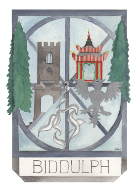
Biddulph
This sign is on the corner of Congleton Road and Woodhouse Lane.
Frame: Elongated winding wheel from mine workings (see original in the Town Hall garden (Map ref. 884 577) to reflect the area’s mining heritage.
Building: St Lawrence’s Parish Church (Map ref. 890 591)
Feature: China, Biddulph Grange Gardens, National Trust (Map ref. 893 593)
Feature: Water to represent the wells, spouts and source of the River Trent
Trees: Wellingtonia found in Biddulph Grange Gardens, National Trust (Map ref. 893 593)
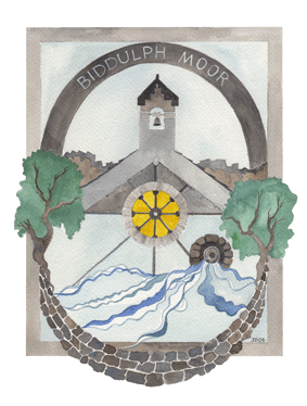
Biddulph Moor
The sign is on the Village Green at the junction of Woodhouse Lane and New Street.
Frame: Dry stone walls – a feature of the Moorlands area. Biddulph Moor provided the valley with most of the stone used throughout the area and also some of the skilled stone masons who worked on projects locally and beyond.
Building: Christ Church designed by Edward Cook. (Map ref. 907 583) The rose window is yellow to represent the sun rising over the Moor
Feature: Skyline of rocks – Troughstones (Map ref. 906 596) and Wicklestone Rocks at Rock End (Map ref 898 568)
Feature: The source of the River Trent (Map ref 905 579) and the source of the Biddulph Brook.
Trees: Hawthorn
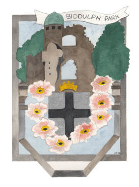
Biddulph Park
This sign is opposite the Biddulph Park Church.
Frame: Stone work around the trough in Grange Road (Map ref. 896 605)
Coat of Arms: de Overton, the family which originally owned land in this part of the valley
Building: Biddulph Old Hall (Map ref. 894 602) Please note, the hall is private property
Feature: The Butter cross or Shepherd’s Cross on Grange Road (Map ref. 896 605). The crown represents the Royalist connection in the English Civil War.
Feature: Roses to represent the plague which affected families in this and other areas
Trees: Horse Chestnuts
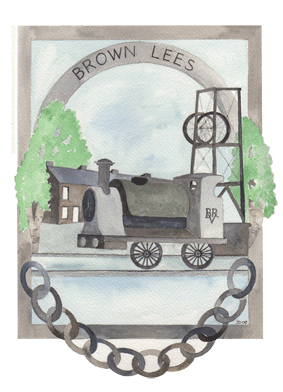
Brown Lees
The sign is on the green next to the Brown Lees Chapel building on the junction of Towerhill Road and Newpool Terrace.
Frame: Chain which was made there together with other metal goods
Building: Terraced housing built to accommodate local workers (Map ref. 878 558)
Feature: Locomotive which hauled goods along the Biddulph Valley Railway
Feature: Winding gear for the Victoria colliery (map ref. for original site 878 555)
Trees: Silver birch
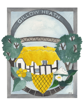
Gillow Heath
The sign is on the carpark next to the Staffordshire Knot.
Frame: Railway track because of the station which stood here (Map ref. 881 584)
Coat of Arms: Mainwaring – the original family owners of this area.
Building: The White House, oldest dwelling in the valley built around 1580. (Map ref. 879 581) NB a private house
Feature: Bridge which crosses the Biddulph Valley Way between Washington Close and Halls Road playing fields. (Map ref. 882 584)
Feature: Buttercups and bindweed which are most common along the Biddulph Valley Walkway
Trees: Oaks (Akesmore Lane – Map ref. 876 577 means oak marsh)
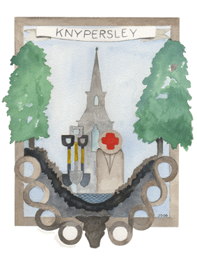
Knypersley
The sign is in the garden which faces Tunstall Road at the junction with Newpool Road.
Frame: decorative stonework in Church Hall wall (Map ref. 880 567)
Coat of Arms: de Knypersley whose family owned the land
Building: St John the Evangelist Church (Map ref. 881 568)
Feature: Rocks Knypersley means “rocky meadow”
Feature: Water, Knypersley Pool (Map ref. 896 548 ) to be found in Greenway Country Park
Feature: Spades – part of the de Knypersley Coat of Arms.
Feature: Red Cross, a plague stone in the Church yard. (Map ref. 881 568)
Feature: Bull’s head made by Edward Cook as part of decorative feature now in grounds of Knypersley First School and visible from pavement next to top entrance (Map ref. 880 566)
Trees: Limes, planted by Bateman family.
